Friday, March 30, 2012

Was it March or May?

Well, we will not have the official statistics for the month of March until Monday, but there is no doubt it has been incredibly warm.  Just how warm you ask?  Here is a brief rundown of some of the staggering facts from March 2012.

This month in Greenville.....
  • there have been 18 days in which a high temperature of 75 degrees or greater has been recorded
  • of those 18, 6 have topped at least 80 degrees
  • for the month, there have only been 6 days in which the high has not reached at least 70 degrees
  • there have only been 2 days in which the high temperature has not reached at least 60 degrees
  • those 2 days were also the only times in which the daytime high fell below the daily average
We still have one day left in the month, but it will just be another statistic added to the pot.  Highs tomorrow will soar into the lower and even middle 80's.

Now since 2012 has basically skipped winter, does that mean this summer will be longer and hotter?  Well not exactly!  Climatology actually suggests that it will be fairly similar to most typical summers.  Check out these findings from the National Weather Service.

Friday, March 16, 2012

Wow! It's Warm Out There!

So is it really only March 16th?  Well Mother Nature is certainly not keeping in touch with "reality."  A summer-like pattern has already setup across much of the central and eastern half of the country.  Record highs have been falling like dominoes. Chicago, IL for example recorded highs over 80 degrees for the last 2 days.  Even Minneapolis, MN reached 73 on Tuesday, crushing their old record of 64.  The Delta has remained toasty as the words "muggy" and "pop up afternoon thunderstorms" have already been consistently in the forecast. 

So why so warm?  Simple, it's the jet stream, those high speed winds in the upper level of the atmosphere that essentially separate the cold and warm airmasses.  Whenever the jet stream pushes further to the south, the cold air goes with it and vice versa.  A dip in the jet stream is referred to as a "trough," whereas a northward bulge is a "ridge."  We are clearly under a ridge (see image below).  When a trough pushes to the east and clashes with the warm air of a ridge, very stormy weather can result.  For now, the pattern will not change as the jet stream will continue to stay put.  Things may be changing once we get into the middle of next week.  Stay tuned!

Friday, March 9, 2012

A Look at March so Far...

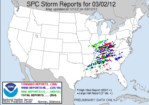
Well last week March roared in like a lion, bringing severe weather to Mississippi and much of the eastern half of the country.  There were a few tornado reports in the Magnolia State, but the worst of the weather was in Tennessee, Kentucky, Indiana, and Ohio.  Several tornadoes caused extensive damage.  One of the most destructive ripped through Henryville, IN.  A confirmed EF-4 tornado with winds of 170 mph killed 1 person and destroyed the town's high school.  The same storm produced another tornado in Marysville, IN.  "Marysville is completely gone" were the grim words spoken by the sheriff's department after that tornado struck.  In all, nearly 40 deaths were blamed on the storm system.  Historically, for early March, it was the second deadliest day for severe weather.  The March 3, 1966 "Candlestick Park" tornado killed 57 people in Mississippi and 1 in Alabama..  Here are the storm reports from March 2nd.  Tornado reports are indicated in red, hail reports in green, and wind reports in blue:


Luckily the weather will be a little less active to finish this week.  The same storm system that brought 1 to 2 inches of rain to some communities last night will bring another good soaking Sunday night and into Monday.  The rain is good news for the Delta as many locations are already well below normal on rainfall for the year.  Before the rain began on Friday, the deficit in Greenville was 6.21 inches; whereas Greenwood stood at 3.65 inches below normal. Too much rain at once will lead to problems for farmers as they continue to work in preparation for the upcoming growing season.  March is actually the wettest month of the year.  Here is how March stacks up to the rest of the year....


Friday, March 2, 2012

Severe Weather: Maybe, Maybe Not

Severe weather has once again been in the news as violent tornadoes have left destruction in several Midwestern communities.  Unfortunately, the threat for severe weather is back in the forecast as another powerful storm system is expected to sweep across the country.  While the worst of the weather will be to our north and east (see the Storm Prediction Center's Outlook for today), the Delta is still under the gun for some nasty weather.....or maybe not!  The caveat in this forecast will be where the storms intially develop.  To keep it simple, severe thunderstorms require warm, moist air accompanied by strong wind shear.  Basically, they need A LOT of energy.  As this energy builds up, storms form in response.  Think of the atmosphere as a pot of boiling water, if you put a lid on it, steam will build up inside the pot.  Over time, enough pressure will build causing the lid to blow off, spilling water everywhere!  The "lid" in the atmosphere must also blow off for severe thunderstorms to develop. Meteorologists refer to this as a "capping inversion."  This feature can make or break a forecast.  Now tomorrow, the energy may not build up quick enough for storms to develop in the Delta; especially if the cold front moves through at a faster clip.  For example, check out the differences in these two model runs from yesterday at noon; the first is faster, while the second is slower.  Both models indicate the total rainfall accumulation over 3 hours.

The GFS model at 3pm Friday
The NAM model at 6pm Friday
 If the GFS is correct, storms will develop east and south of the Delta.  If the NAM is correct, storms will fire over the central Delta.  Right now, I personally believe the storms will initiate east and southwest of the River (more in alignment with the GFS model), so communities from Greenville, to Cleveland and Clarksdale may actually miss out on the severe weather, whereas areas south and east of Greenville may experience a few stronger storms.  This would include Indianola, Greenwood, Grenada, and Yazoo City.
Stay tuned to WXVT throughout the day as we will keep you updated on the complex forecast!

Tuesday, February 21, 2012

So I have decided to start a weather blog to provide a deeper discussion on the ever changing atmosphere. I am by no means an expert, but writing about the weather will not only help better inform others, but also help educate myself. As someone who has been out of school for about 9 months now, I am still learning how to become a better meteorologist.

Since the weather this winter has been anything but normal, my focus for post #1 will be the short-term forecast and primarily the threat for severe weather on Thursday and Thursday evening.

As of Tuesday evening, the forecast models are bringing a fairly potent storm system into the area around day's end on Thursday. Now when I say "models", there are many, but some are more commonly used. The NAM and GFS are used most often by forecasters, but the European and Canadian models can also provide critical information as well. The NAM and Canadian are generally used to forecast weather over the next couple of days, while the GFS and European can be used to forecast in the long term. Simply put, these "models" take the current state of the atmosphere and apply complex equations to predict how it will change. One of the most important things to understand is "garbage in, garbage out." If bad data is entered into a model, a poor forecast will result. No matter what, no single model is ever truly "correct." There are many circumstances in which certain models may perform better depending on the impending weather event, but there are no guarantees. Sometimes models just have bad runs...it's all about recognizing the trends!

Now back to the forecast at hand....

What is drawing my eye to Thursday's possible severe weather threat is how several variables among the different models are coming together in agreement....Key words are "coming together." As of right now, the main threats will be strong wind and hail. While a few weak spin-ups could be possible, the setup does not shout tornado! Rather a squall line seems more likely. Two variables I will be considering are instability and atmospheric wind shear. When instability (rising air) is overlaid with wind shear, the weather can get pretty nasty. Warm temperatures + humid air + wind shear = possible severe thunderstorms! This might be the case Thursday night.
Now the reason I am not too concerned about a tornado threat is because the center of low pressure will be just north of Lake Superior. In general, tornado are more favorable close to the center of the low, near the warm front. Now this does not mean the Great Lakes will be experiencing tornadic thunderstorms (remember we need BOTH instability (which they will not have) and wind shear to raise the threat). That's all for now, but tomorrow I will provide even more details on Thursday's forecast. For the time being, enjoy the sunshine and warm weather for your Wednesday!